Posts

News from the wires: Modern humans reached westernmost Europe 5,000 years earlier than previously known

Image
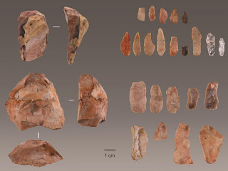
This is the first in what I hope will be a regular series highlighting new history and archaeology research from around the world, the common denominator being that I find them particularly interesting! New research provides definitive evidence that modern humans were on the Atlantic coast of modern-day Portugal at a time when, if present at all, Neanderthal populations would have been extremely sparse. The discovery has important ramifications for our understanding of the process of modern human dispersal and replacement of Neanderthal populations. The results support a very rapid, unimpeded dispersal of modern humans across western Eurasia and support the notion that climate and environmental change played a significant role in the process. According to the findings, modern humans probably arrived in the westernmost part of Europe 41,000 - 38,000 years ago, about 5,000 years earlier than previously known. An international team of researchers revealed the discovery of stone tools used

Visiting Brompton Road disused tube station

Image
The Covid-19 lockdown and economic downturn have affected most strands of society, including museums and other cultural venues. How can they remain relevant in a post pandemic world while trying to generate much needed income? A dynamic digital offering is one answer. London Transport Museum is trying just that with a series of 'virtual' tours from its Hidden London portfolio ; in effect, an intimate series of Zoom meetings focused on two disused underground stations that can't be visited in real life. At £30 a head, these aren't particularly cheap but I couldn't resist buying a ticket to find out if an online visit was worth it. I chose a visit to Brompton Road, a Leslie Green designed station on the Piccadilly line which was open to passengers between 1906 and 1934 (the other available tour is of King William Street station). Passenger numbers at Brompton Road were lower than expected for a station initially built with four lifts (it gradually lost these and other

Victorian post boxes

Image
Familiar, but not mundane They are among our most familiar items of street furniture; indeed there are more than 115,000 throughout the UK. Yet how many of us walk past a post box without considering how long it might have been there? Pillar boxes have been a feature of our streets since the 1850s, when demand for postal services grew following the introduction of the Penny Post in 1840. The novelist Anthony Trollope is remembered as the Post Office official responsible for recommending the introduction of pillar boxes to allow easier posting of private letters. These were first installed on the Channel Islands in 1852, though were introduced to the mainland the following year. Early boxes were green, but red had become the standard colour by 1879. Here are a selection of boxes bearing the VR cipher of Queen Victoria, a little slice of everyday Victorian history. Abingdon (Conduit Road): Abingdon (St Helen's Wharf): Appleton: Bangor (Wales): Great Yarmouth:

Many urban rivers are hidden underground – 'daylighting' them would bring nature back to cities

Image
The hidden rivers of London, such as the Fleet, the Tyburn and the Walbrook, are pretty famous, but they aren't examples of a rare phenomenon - as my fascination with the Farset in Belfast and the Stert in Abingdon can testify. We have been burying and managing waterways in numerous places for as long as we have needed to live in places.  Read on for an illuminating article by David N Lerner, Emeritus Professor of Environmental Engineering at the University of Sheffield. The article is republished from The Conversation under a Creative Commons license. Read the original article , published in December 2019. Two small rivers meet in the ‘Cathedral’ under Bradford city centre. Martyn Sutcliffe , Author provided David N Lerner , University of Sheffield Ever noticed how few rivers you can see in most city centres? It’s easy enough to spot the big, usually tamed, main river such as the Thames in London, the Seine in Paris, the Aire in Leeds or the Don in Sheffield. But you

From Victorian water works to a community hub...

Image
Is this a surprising change of use for a Victorian building? An insight into how Oxford once managed its water supplies... View this post on Instagram The South Oxford community centre in Lake Street, #Oxford was originally built in 1856 as a pumping station for the city waterworks. Water was pumped from the neighbouring Hinksey reservoir, itself only formed in 1850 as a result of gravel extraction for an extension of the railway from Oxford to Banbury. The waterworks were in operation until 1934. Its cooling lake is now the boating lake in Hinksey park and filter beds were converted to swimming pools. #history #urbanhistory #Victorian #architecture A post shared by bishib70 (@landscapeandhistory) on Oct 14, 2019 at 12:48pm PDT Lake Street front: See the OS 25 inch map of the area from 1898.

Ghost road

Image
Roads cut through landscapes. They fragment wildlife habitats. They take us places. They connect neighbourhoods. Some seem like permanent fixtures but over time they've been re-aligned or blocked off or closed completely. Sometimes a hint of a road's former existence can still be found in the landscape. Reproduced with the permission of the National Library of Scotland. Click on the image to go through to the wonderful side-by-side viewer on their website The road name 'Lane End' in Crowmarsh Gifford, Oxfordshire today reminds us that it once served as the junction of Broom's Lane (now Clack's Lane) with the Wallingford-Henley Road. It was removed when the A4074 road was built, with Clack's Lane finishing at the Port Way roundabout instead. From aerial views a faint trace of its former route can be glimpsed, a ghost road if you like. A whisper even remains on the ground.

What's in a name? Blake's Oak near Abingdon

Image
"One Blake hung upon an oak in the way to Abingdon, beyond the half-way gate. This traitor betrayed three Christian kings, and would have betrayed the fourth ; upon which he was hanged, within two days after his design was discovered, upon the said oak, which is still called 'Blake's Oak.'  The wood was formerly a haunt of robbers, and here St. Edward of Abingdon was once attacked by them, but his protestations of poverty being found to be true, he was allowed to proceed unharmed."  A Handbook for Travellers in Berks, Bucks, and Oxfordshire , London: J. Murray, 1860 A very small copse named Blake's Oak exists on land north of Abingdon near to where a proposed large housing development will be built. It lies relatively close to the slightly bigger Sugnell Copse and is adjacent to the main Oxford to Abingdon road. The OS Six Inch map (1888-1913) shows what is still effectively the modern extent of both copses (though I wonder if both copses were once join