Posts

From Victorian water works to a community hub...

Image
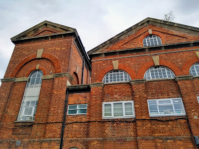
Is this a surprising change of use for a Victorian building? An insight into how Oxford once managed its water supplies... View this post on Instagram The South Oxford community centre in Lake Street, #Oxford was originally built in 1856 as a pumping station for the city waterworks. Water was pumped from the neighbouring Hinksey reservoir, itself only formed in 1850 as a result of gravel extraction for an extension of the railway from Oxford to Banbury. The waterworks were in operation until 1934. Its cooling lake is now the boating lake in Hinksey park and filter beds were converted to swimming pools. #history #urbanhistory #Victorian #architecture A post shared by bishib70 (@landscapeandhistory) on Oct 14, 2019 at 12:48pm PDT Lake Street front: See the OS 25 inch map of the area from 1898.

Ghost road

Image
Roads cut through landscapes. They fragment wildlife habitats. They take us places. They connect neighbourhoods. Some seem like permanent fixtures but over time they've been re-aligned or blocked off or closed completely. Sometimes a hint of a road's former existence can still be found in the landscape. Reproduced with the permission of the National Library of Scotland. Click on the image to go through to the wonderful side-by-side viewer on their website The road name 'Lane End' in Crowmarsh Gifford, Oxfordshire today reminds us that it once served as the junction of Broom's Lane (now Clack's Lane) with the Wallingford-Henley Road. It was removed when the A4074 road was built, with Clack's Lane finishing at the Port Way roundabout instead. From aerial views a faint trace of its former route can be glimpsed, a ghost road if you like. A whisper even remains on the ground.

What's in a name? Blake's Oak near Abingdon

Image
"One Blake hung upon an oak in the way to Abingdon, beyond the half-way gate. This traitor betrayed three Christian kings, and would have betrayed the fourth ; upon which he was hanged, within two days after his design was discovered, upon the said oak, which is still called 'Blake's Oak.'  The wood was formerly a haunt of robbers, and here St. Edward of Abingdon was once attacked by them, but his protestations of poverty being found to be true, he was allowed to proceed unharmed."  A Handbook for Travellers in Berks, Bucks, and Oxfordshire , London: J. Murray, 1860 A very small copse named Blake's Oak exists on land north of Abingdon near to where a proposed large housing development will be built. It lies relatively close to the slightly bigger Sugnell Copse and is adjacent to the main Oxford to Abingdon road. The OS Six Inch map (1888-1913) shows what is still effectively the modern extent of both copses (though I wonder if both copses were once join

Tracking the river Farset on old OS maps

Image
Continuing my effort to track the course of Belfast's river Farset, I've been looking at the PRONI historical maps viewer to see some of the old OS maps coverage of the city and environs. Frustratingly, it's not possible to embed the maps or share screengrabs without breach of OSNI copyright. Some interesting snippets:  Use of what appears to be the Farset's course as a parish boundary is striking. Also the array of industry from brickworks to distilleries. On the OSNI Historical First Edition (1832-1846) is the notation "Stream goes under ground" near the quarries on Squire's Hill.  There are an array of streams in the area, some of which must come together to form the Farset. An ice house is marked on the location of modern day housing on Bombay Street. Is it related to the nearby Clonard House? By the third edition (1900-1907), the housing has been constructed. Victoria Street and Queen's Square are constructed by the time of the seco

Mapping Belfast's hidden river Farset

Image
The Farset is the now mostly underground river that is said to give Belfast its name*. There has been talk of 'daylighting' the river in places, ie uncovering it from its culverted fate to flow openly again. This could boost nature and air quality and also potentially alleviate flood risk. Belfast's underground rivers have been linked to some of the flooding experienced by the city. Most articles about the Farset focus on the stretch from High Street to the Lagan. While it's not universally known that a river of some importance in the city's development once flowed here, I'm betting a fair few High Street shoppers know of its existence underfoot. But on the Google Map below I've expanded outwards to try to map some of the Farset's known locations along its whole course, while guessing at a few more. " The lost river that gave Belfast its name " is an interesting 2013 article from the Belfast Telegraph  which has provided the basis for many

Dunluce Castle, from medieval history to modern day myth

Image
Built between the 15th and 17th centuries upon basalt cliffs along the dramatic north Antrim coast of Ireland, this was a former stronghold of the famed Clan MacDonnell, a sept of the Scottish Clan Donald. Dunluce Castle was first built by their rivals the MacQuillan family circa 1500 (on the site of an earlier Norman settlement), before the MacDonnells seized it around 50 years later. Sorley Boy MacDonnell ( Scottish Gaelic Somhairle Buidhe MacDonnell) effectively established the Clan MacDonnell as powerful rulers in Antrim; his father having been lord of Islay and Kintyre just across the sea (so close that the isle of Islay is visible from Dunluce). After defeating the MacQuillans in 1558, Sorley Boy's next great rival was to be the Gaelic chieftain Shane O'Neill, who took him captive in 1565 before he himself was murdered by MacDonnells in 1568.  At various times the MacDonnells were in conflict with English forces, and Sorley Boy's wife and children were among the

FitzHarris castle mound, Abingdon, LiDAR

Image
A residential area of Abingdon in Oxfordshire retains the hint of how the landscape was shaped in the age of William the Conqueror. Land here was awarded to a knight following the Norman invasion of 1066, upon which was constructed a motte and bailey. A small river, the Stert, flowed beside it and served as a moat. The motte and bailey was later abandoned in favour of a medieval house, later known as FitzHarris manor house (or Fitzharry's) built a short distance away. Subsequent developments, including massive expansion of housing in the 20th century, has obliterated much of the old landscape. However that old Norman motte is still there, now largely overgrown by trees and difficult to see. You might not even realize it's there. The LiDAR image below shows the extent of the motte and the clearing some 100 yards away where the grounds of the old manor house used to be (later rebuilt, it was finally demolished in 1953 having fallen into disrepair after the rest of the estate