Posts

What's in a name? Blake's Oak near Abingdon

Image
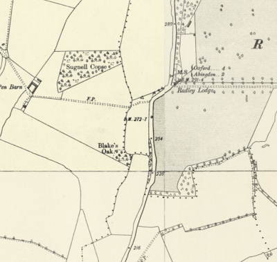
"One Blake hung upon an oak in the way to Abingdon, beyond the half-way gate. This traitor betrayed three Christian kings, and would have betrayed the fourth ; upon which he was hanged, within two days after his design was discovered, upon the said oak, which is still called 'Blake's Oak.'  The wood was formerly a haunt of robbers, and here St. Edward of Abingdon was once attacked by them, but his protestations of poverty being found to be true, he was allowed to proceed unharmed."  A Handbook for Travellers in Berks, Bucks, and Oxfordshire , London: J. Murray, 1860 A very small copse named Blake's Oak exists on land north of Abingdon near to where a proposed large housing development will be built. It lies relatively close to the slightly bigger Sugnell Copse and is adjacent to the main Oxford to Abingdon road. The OS Six Inch map (1888-1913) shows what is still effectively the modern extent of both copses (though I wonder if both copses were once join

Tracking the river Farset on old OS maps

Image
Continuing my effort to track the course of Belfast's river Farset, I've been looking at the PRONI historical maps viewer to see some of the old OS maps coverage of the city and environs. Frustratingly, it's not possible to embed the maps or share screengrabs without breach of OSNI copyright. Some interesting snippets:  Use of what appears to be the Farset's course as a parish boundary is striking. Also the array of industry from brickworks to distilleries. On the OSNI Historical First Edition (1832-1846) is the notation "Stream goes under ground" near the quarries on Squire's Hill.  There are an array of streams in the area, some of which must come together to form the Farset. An ice house is marked on the location of modern day housing on Bombay Street. Is it related to the nearby Clonard House? By the third edition (1900-1907), the housing has been constructed. Victoria Street and Queen's Square are constructed by the time of the seco

Mapping Belfast's hidden river Farset

Image
The Farset is the now mostly underground river that is said to give Belfast its name*. There has been talk of 'daylighting' the river in places, ie uncovering it from its culverted fate to flow openly again. This could boost nature and air quality and also potentially alleviate flood risk. Belfast's underground rivers have been linked to some of the flooding experienced by the city. Most articles about the Farset focus on the stretch from High Street to the Lagan. While it's not universally known that a river of some importance in the city's development once flowed here, I'm betting a fair few High Street shoppers know of its existence underfoot. But on the Google Map below I've expanded outwards to try to map some of the Farset's known locations along its whole course, while guessing at a few more. " The lost river that gave Belfast its name " is an interesting 2013 article from the Belfast Telegraph  which has provided the basis for many

Dunluce Castle, from medieval history to modern day myth

Image
Built between the 15th and 17th centuries upon basalt cliffs along the dramatic north Antrim coast of Ireland, this was a former stronghold of the famed Clan MacDonnell, a sept of the Scottish Clan Donald. Dunluce Castle was first built by their rivals the MacQuillan family circa 1500 (on the site of an earlier Norman settlement), before the MacDonnells seized it around 50 years later. Sorley Boy MacDonnell ( Scottish Gaelic Somhairle Buidhe MacDonnell) effectively established the Clan MacDonnell as powerful rulers in Antrim; his father having been lord of Islay and Kintyre just across the sea (so close that the isle of Islay is visible from Dunluce). After defeating the MacQuillans in 1558, Sorley Boy's next great rival was to be the Gaelic chieftain Shane O'Neill, who took him captive in 1565 before he himself was murdered by MacDonnells in 1568.  At various times the MacDonnells were in conflict with English forces, and Sorley Boy's wife and children were among the

FitzHarris castle mound, Abingdon, LiDAR

Image
A residential area of Abingdon in Oxfordshire retains the hint of how the landscape was shaped in the age of William the Conqueror. Land here was awarded to a knight following the Norman invasion of 1066, upon which was constructed a motte and bailey. A small river, the Stert, flowed beside it and served as a moat. The motte and bailey was later abandoned in favour of a medieval house, later known as FitzHarris manor house (or Fitzharry's) built a short distance away. Subsequent developments, including massive expansion of housing in the 20th century, has obliterated much of the old landscape. However that old Norman motte is still there, now largely overgrown by trees and difficult to see. You might not even realize it's there. The LiDAR image below shows the extent of the motte and the clearing some 100 yards away where the grounds of the old manor house used to be (later rebuilt, it was finally demolished in 1953 having fallen into disrepair after the rest of the estate

Joe's Hill, Cloughreagh - what's in a name?

Though it bears the name "McKnights Hill" today, Joe's Hill is the only name I've ever known for the B road linking Derrymore Road (beside the modern St Peter's Primary School) with Millvale Road in Cloughreagh townland outside Bessbrook in County Armagh (Northern Ireland). I've never, however, seen it named Joe's Hill on any map, including the excellent  historical maps available through the PRONI website  - it's just how I knew it growing up. Is this how others knew it? What can the maps tell us about its name, local or official? The earliest of these maps online is the OSNI historical first edition dated 1832-1846 and the road I know as 'Joe's Hill' is there, opposite the site of Derrymore House (now managed by the National Trust). On this map, and the 1846-62, version it appears to run awkwardly to an entrance by a gate lodge on the Derrymore House estate. I don't think a trace of this exists today. Beside its junction with Derr

A bit of industrial history lost from Millvale Road

Catching up on my old home area: I see the old Atkinson's corn mill on the Millvale Road near the crossroads with Joe's Hill and the Doctor's Hill was demolished in 2014 and work is underway on a new housing development. The mill was in a terrible state so it's no surprise to see it demolished. However this little slice of local history can still be viewed in its dilapidated state on historical Street View imagery. The image below is from Google maps imagery dated 2009: Here is the same stretch from 2016: One of the houses on the opposite side of the road has been renovated but the other is even more overgrown. Here is the 2009 imagery from the other direction, showing the spot where the old Bessbrook-Newry tram crossed the Millvale Road and Bessbrook river: Many thanks to Google for making such imagery available for embedding.