Posts

FitzHarris castle mound, Abingdon, LiDAR

Image
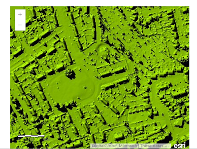
A residential area of Abingdon in Oxfordshire retains the hint of how the landscape was shaped in the age of William the Conqueror. Land here was awarded to a knight following the Norman invasion of 1066, upon which was constructed a motte and bailey. A small river, the Stert, flowed beside it and served as a moat. The motte and bailey was later abandoned in favour of a medieval house, later known as FitzHarris manor house (or Fitzharry's) built a short distance away. Subsequent developments, including massive expansion of housing in the 20th century, has obliterated much of the old landscape. However that old Norman motte is still there, now largely overgrown by trees and difficult to see. You might not even realize it's there. The LiDAR image below shows the extent of the motte and the clearing some 100 yards away where the grounds of the old manor house used to be (later rebuilt, it was finally demolished in 1953 having fallen into disrepair after the rest of the estate

Joe's Hill, Cloughreagh - what's in a name?

Though it bears the name "McKnights Hill" today, Joe's Hill is the only name I've ever known for the B road linking Derrymore Road (beside the modern St Peter's Primary School) with Millvale Road in Cloughreagh townland outside Bessbrook in County Armagh (Northern Ireland). I've never, however, seen it named Joe's Hill on any map, including the excellent  historical maps available through the PRONI website  - it's just how I knew it growing up. Is this how others knew it? What can the maps tell us about its name, local or official? The earliest of these maps online is the OSNI historical first edition dated 1832-1846 and the road I know as 'Joe's Hill' is there, opposite the site of Derrymore House (now managed by the National Trust). On this map, and the 1846-62, version it appears to run awkwardly to an entrance by a gate lodge on the Derrymore House estate. I don't think a trace of this exists today. Beside its junction with Derr

A bit of industrial history lost from Millvale Road

Catching up on my old home area: I see the old Atkinson's corn mill on the Millvale Road near the crossroads with Joe's Hill and the Doctor's Hill was demolished in 2014 and work is underway on a new housing development. The mill was in a terrible state so it's no surprise to see it demolished. However this little slice of local history can still be viewed in its dilapidated state on historical Street View imagery. The image below is from Google maps imagery dated 2009: Here is the same stretch from 2016: One of the houses on the opposite side of the road has been renovated but the other is even more overgrown. Here is the 2009 imagery from the other direction, showing the spot where the old Bessbrook-Newry tram crossed the Millvale Road and Bessbrook river: Many thanks to Google for making such imagery available for embedding.

Within the Black Mountains

Image
Llanthony Priory, nestled in a valley in the Black Mountains, is thrilling to behold from the top of Hatterall Ridge. We walked along the ridge from Hay Bluff on a beautiful spring day. The Augustinian priory has Grade I listed status. First founded in the 12th century but extended in later medieval period.

The Crum / Belfast Gaol

Image
I recently enjoyed a tour of the former Crumlin Road Gaol in Belfast so was interested to see the following sketches from Sir Charles Lanyon when they appeared among recent Flickr uploads from PRONI. The prison opened in 1846 and only closed in 1996, having fallen into considerable disrepair. The building, which has 'accommodated' in one form or another some of Ireland's most famous politicians, now has Grade A listed status. Here's one of my own photos from the yard just before a cloud burst! Hopefully I'll sort out some more soon, including from inside the tunnel: See more about the gaol, including details of tours

The 15th Royal Irish Rifles in the Great War

This map shows some of the places where the 15th RIR battalion were located during service in France and Flanders.   The 15th Royal Irish Rifles battalion was first posted to France and Flanders in October 1915, and remained active until the end of the Great War. Location information is primarily taken from Cyril Falls' A History of the 36th (Ulster) Division , first published in 1922. Other sources include the service record of Rfn William Cowan, from 1915 to 1919, and the diary of Private Harold Tugwell, details of which were posted online on the Great War Forum. View 15th Battalion Royal Irish Rifles WWI in a larger map

Tyneham ghost village remembered

Image
ITV Meridian News this week remembered the 70th anniversary of the eviction of villagers from Tyneham, Dorset by the War Office for use as a military training ground. (The surrounding Lulworth ranges area is still used for military training today). What was initially thought a temporary move during the remainder of the Second World War was made permanent by compulsory purchase order of the land in 1948. The buildings of Tyneham now lie dormant, mostly in ruins (some presumably damaged by military exercises!), although the church is now preserved and the striking telephone kiosk is a modern replica. Access is available during part of the year when military training is not taking place. The following pictures were taken in June 2010.